Guide to marine forecasts
The guides below will provide you with a description of what you will see on the marine weather pages, with details of how to view or change your view of the content.
The Met Office provides a wide range of marine forecasts and warnings.
This guide will help you to understand the forecasts and warnings we provide, and explain terms which are used to convey specific meanings.
This includes information about how to view the forecasts, the Beaufort scale, a glossary of terms used and radio broadcast times for weather bulletins.
There are four sets of forecasts and warnings:
- Shipping forecast key
- Inshore waters forecast key
- High seas forecast key
- Extended outlook forecast key
How to view the forecasts
The example below shows the shipping forecasts and gale warnings page but the information applies to all four marine forecast pages.
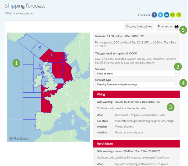
1. A clickable map is used to display the warnings. Areas of the map are coloured red when a warning is in force. Selecting an area on the map will display the forecast for that area in the table to the right of the map.
2. You can choose to select any individual area for display. Areas and type of forecast can be selected using the drop down boxes.
3. The details of the forecast or warning for your selected area will appear here.
4. Toggle between the type of forecasts you wish to display by using these buttons.
5. There is a printable view which contains the forecast for all areas.
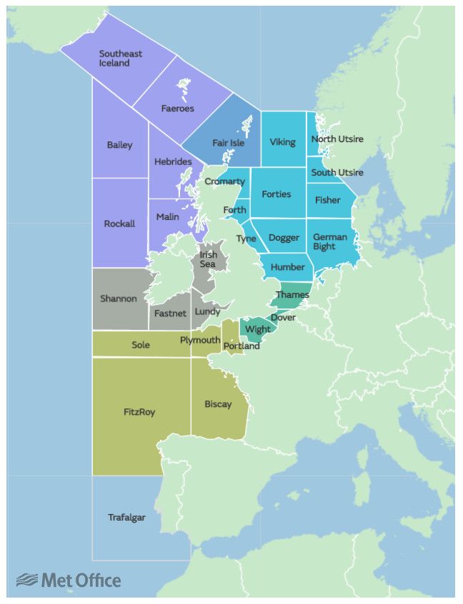
Guide to the shipping forecast
The shipping forecast is issued four times a day and covers a period of 24 hours from 0000 UTC, 0600 UTC, 1200 UTC and 1800 UTC.
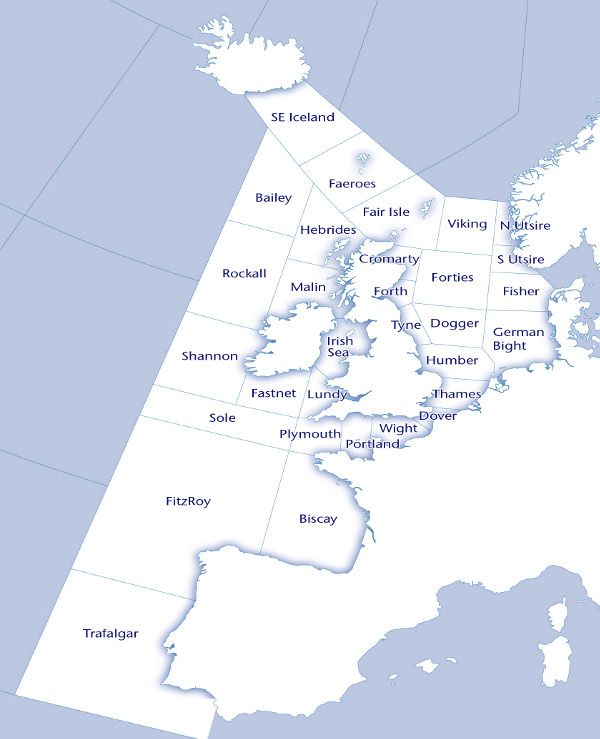
The waters around the British Isles are divided into 31 sea areas shown on the map.
The forecast contains details of gale warnings in force, a general synopsis and sea-area forecasts containing forecast wind direction and force, weather and visibility.
Gale warnings
Gale warnings are both incorporated as part of the Shipping Forecast and issued independently as required throughout the day (for winds of Gale Force 8 or more).
Advice Note 1033 - Maritime Safety Information (MSI) Leaflet
Guide to the inshore waters forecast
Forecasts for UK inshore waters are issued four times a day and cover a period of 24 hours from 0000, 0600, 1200 and 1800 UTC.
The coastal waters, up to 12 miles offshore, around the British Isles are divided into 19 areas shown on the map.
The forecast contains details of forecast wind direction and force, weather, visibility and sea state.
Strong coastal winds
Strong coastal winds (Strong Breeze force 6 or more) are displayed for the first 24 hours of the inshore waters forecast. These are displayed with the Inshore waters forecast.
Advice Note 1033 - Maritime Safety Information (MSI) Leaflet
Guide to the high seas forecast
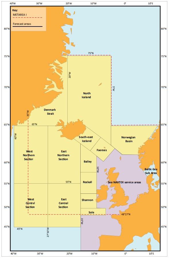
Forecasts for the high seas are issued twice a day at 0930 and 2130 GMT and covers the next 24 hours and outlooks for the following 24 hours.
The part of the North Atlantic known as Metarea I is divided into 13 sea areas shown on the map. Six of the areas are also in the Shipping forecast.
The forecast contains a general synopsis and sea-area forecasts containing forecast wind direction and force, weather and visibility for the next 24 hours with an outlook for the following 24 hours.
Storm warnings
Storm warnings are issued as required throughout the day (for winds of Storm force 10 or more).
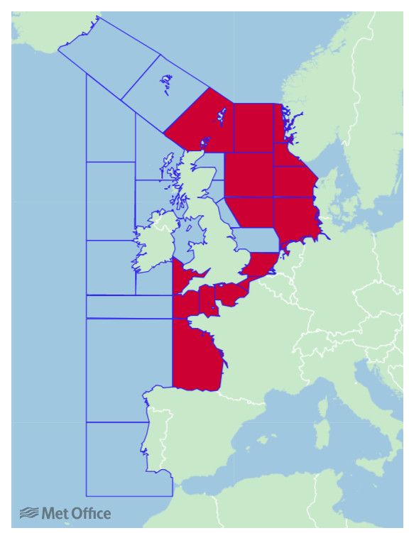
These are displayed with the High seas forecast. This example shows storm warnings in force for the East Northern section.
Guide to the extended outlook forecast
The extended outlooks are issued once a day, at 2300, GMT and cover the next 3 to 5 days.
The waters around the British Isles are divided into 3 areas shown on the map; these areas reflect the coverage areas of the UK′s Navtex transmitters, with overlaps as appropriate.
The forecast contains details of the likelihood of gales or storms, a general synopsis and a general forecast for the area of coverage of each Navtex transmitter.
Beaufort wind force scale
The Beaufort scale, which is used in Met Office marine forecasts, is an empirical measure for describing wind intensity based on observed sea conditions.
Specifications and equivalent speeds
| Beaufort wind scale | Mean Wind Speed | Limits of wind speed | Wind descriptive terms | Probable wave height | Probable maximum wave height | Seastate | Sea descriptive terms | ||
|---|---|---|---|---|---|---|---|---|---|
| Knots | ms-1 | Knots | ms-1 | in metres1 | in metres2 | ||||
| 0 | 0 | 0 | <1 | <1 | Calm | - | - | 0 | Calm (glassy) |
| 1 | 2 | 1 | 1-3 | 1-2 | Light air | 0.1 | 0.1 | 1 | Calm (rippled) |
| 2 | 5 | 3 | 4-6 | 2-3 | Light breeze | 0.2 | 0.3 | 2 | Smooth (wavelets) |
| 3 | 9 | 5 | 7-10 | 4-5 | Gentle breeze | 0.6 | 1.0 | 3 | Slight |
| 4 | 13 | 7 | 11-16 | 6-8 | Moderate breeze | 1.0 | 1.5 | 3-4 | Slight - Moderate |
| 5 | 19 | 10 | 17-21 | 9-11 | Fresh breeze | 2.0 | 2.5 | 4 | Moderate |
| 6 | 24 | 12 | 22-27 | 11-14 | Strong breeze | 3.0 | 4.0 | 5 | Rough |
| 7 | 30 | 15 | 28-33 | 14-17 | Near gale | 4.0 | 5.5 | 5-6 | Rough-Very rough |
| 8 | 37 | 19 | 34-40 | 17-21 | Gale | 5.5 | 7.5 | 6-7 | Very rough - High |
| 9 | 44 | 23 | 41-47 | 21-24 | Strong gale3 | 7.0 | 10.0 | 7 | High |
| 10 | 52 | 27 | 48-55 | 25-28 | Storm | 9.0 | 12.5 | 8 | Very High |
| 11 | 60 | 31 | 56-63 | 29-32 | Violent storm | 11.5 | 16.0 | 8 | Very High |
| 12 | - | 64+ | 33+ | Hurricane | 14+ | - | 9 | Phenomenal | |
Notes
- These values refer to well-developed wind waves of the open sea.
- The lag effect between the wind getting up and the sea increasing should be borne in mind.
- The official term is Strong gale, however, the Met Office uses the descriptive term Severe gale
To convert knots to mph multiply by 1.15, for m/s multiply by 0.514.
Radio broadcast times
BBC Radio 4 broadcasts weather bulletins daily on FM and long wave.
Weather bulletins for shipping are broadcast daily on BBC Radio 4 at the following times:
- 0048 and 0520 (long wave and FM)
- 1201 and 1754 (normally long wave only)
The bulletins consist of a gale warning summary, general synopsis, sea-area forecasts and coastal station reports. In addition, gale warnings are broadcast at the first available programme break after receipt. If this does not coincide with a news bulletin, the warning will be repeated after the next news bulletin.
In addition, some bulletins include a forecast for all UK inshore waters, as distinct from the coastal waters. This can be heard on BBC Radio 4 at the end of programmes (approximately 0048), and on BBC Radio 3 at 0535. The forecast covers the area up to 12 miles offshore and is for the period up to 1800 the next day. It includes a general synopsis, the forecast of wind direction and force, visibility and weather. The broadcast on Radio 4 also includes the latest available reports of wind direction and force, visibility, sea-level pressure and tendency for approximately 20 stations around the UK.
Marine forecasts glossary
Marine forecasts contain a number of terms which are used to convey specific meanings.
At first
0–12 hours (from the start of the 24‑hour forecast period), with “later” = 12–24 hours.
Gale warnings
Gale
Winds of at least Beaufort force 8 (34-40 knots) or gusts reaching 43-51 knots
Severe gale
Winds of force 9 (41-47 knots) or gusts reaching 52-60 knots
Storm
Winds of force 10 (48-55 knots) or gusts reaching 61-68 knots
Violent storm
Winds of force 11 (56-63 knots) or gusts of 69 knots or more
Hurricane force
Winds of force 12 (64 knots or more)
Note: The term used is 'hurricane force'; the term 'hurricane' on its own means a true tropical cyclone, not experienced in British waters.
Imminent
Expected within six hours of time of issue
Soon
Expected within six to 12 hours of time of issue
Later
Expected more than 12 hours from time of issue
Later
“At first” = 0–12 hours (from the start of the 24‑hour forecast period), with “later” = 12–24 hours.
Visibility
Very poor
Visibility less than 1,000 metres
Poor
Visibility between 1,000 metres and 2 nautical miles
Moderate
Visibility between 2 and 5 nautical miles
Good
Visibility more than 5 nautical miles
Movement of pressure systems
Slowly
Moving at less than 15 knots
Steadily
Moving at 15 to 25 knots
Rather quickly
Moving at 25 to 35 knots
Rapidly
Moving at 35 to 45 knots
Very rapidly
Moving at more than 45 knots
Pressure tendency in station reports
Rising (or falling) more slowly
Pressure rising (or falling) at a progressively slower rate through the preceding three hours
Rising (or falling) slowly
Pressure change of 0.1 to 1.5 hPa in the preceding three hours
Rising (or falling)
Pressure change of 1.6 to 3.5 hPa in the preceding three hours
Rising (or falling) quickly
Pressure change of 3.6 to 6.0 hPa in the preceding three hours
Rising (or falling) v. rapidly
Pressure change of more than 6.0 hPa in the preceding three hours
Now rising (or falling)
Pressure has been falling (rising) or steady in the preceding three hours, but at the time of observation was definitely rising (falling)
Note: For those more familiar with the millibar, 1 hPa = 1 mb
Wind
Wind direction
Indicates the direction from which the wind is blowing
Becoming cyclonic
Indicates that there will be considerable change in wind direction across the path of a depression within the forecast area
Veering
The changing of the wind direction clockwise, e.g. SW to W
Backing
The changing of the wind in the opposite direction to veering (anticlockwise), e.g. SE to NE
Sea state
Smooth
Wave height less than 0.5 m
Slight
Wave height of 0.5 to 1.25 m
Moderate
Wave height of 1.25 to 2.5 m
Rough
Wave height of 2.5 to 4.0 m
Very rough
Wave height of 4.0 to 6.0 m
High
Wave height of 6.0 to 9.0 m
Very high
Wave height of 9.0 to 14.0 m
Phenomenal
Wave height more than 14.0 m