
Low level clouds
Clouds with a base below 6,500 ft including cumulus, cumulonimbus, stratocumulus and stratus.
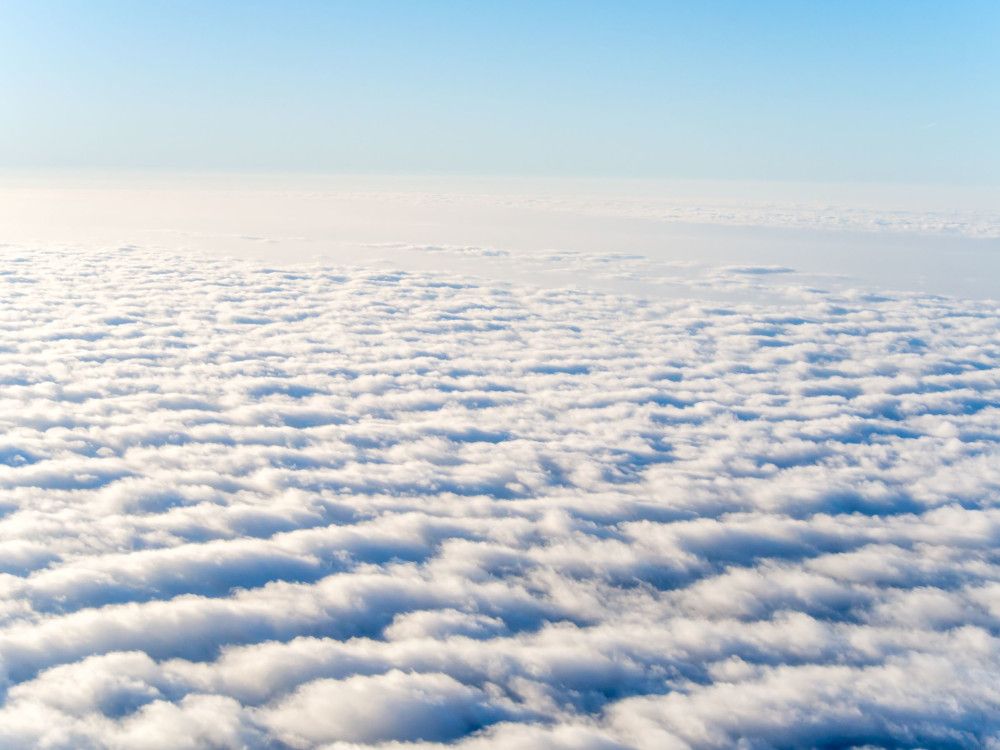
Stratus clouds
- Height of base: 0 - 1,200 ft
- Shape: layered
- Latin: stratus - flattened or spread out
- Precipitation: light
Stratus clouds tend to be featureless, low altitude clouds that cover the sky in a blanket of white or grey. Often the scene of dull, overcast days in its 'nebulosus' form, they can persist for long periods of time. They are the lowest-lying cloud type and sometimes appear at the surface in the form of mist or fog.
How do stratus clouds form?
Stratus clouds form in calm, stable conditions when gentle breezes raise cool, moist air over colder land or ocean surfaces. These clouds can exist in a variety of thicknesses and are sometimes opaque enough to darken days, allowing for little light to pass through.
What weather is associated with stratus clouds?
Stratus is usually accompanied by little to no rainfall but if it is thick enough, it can produce light drizzle. This drizzle can also fall in the form of light snow if cold enough.
How do we categorise stratus clouds?
Due to the nature of stratus it only has two defined species:
- Stratus nebulosus - a featureless, dark layer which is capable of producing drizzle.
- Stratus fractus - a stratus layer which is starting to break up or 'dissipate,' leading to breaks in the cloud.
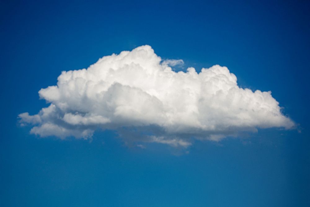
Cumulus clouds
- Height of base: 1,200 - 6,500 ft
- Shape: cauliflower of fluffy
- Latin: cumulus - heap
- Precipitation: occasional rain or snow showers
Cumulus clouds are one of the most common and distinctive types of cloud. These detached, individual, cauliflower-shaped clouds are usually spotted in fair weather conditions. The tops of these clouds are mostly brilliant white tufts when lit by the Sun, although their base is usually relatively dark.
How do cumulus clouds form?
All cumulus clouds develop because of convection. As air heated at the surface is lifted, it cools and water vapour condenses to produce the cloud. Throughout the day, if conditions allow, these can grow in height and size and can eventually form into cumulonimbus clouds.
Along coastlines, cumulus may form over land during daylight hours as a sea breeze brings in moist air, which is then warmed by the surface. This effect reverses overnight as the sea becomes warmer than the land and cumulus form over the sea.
What weather is associated with cumulus clouds?
Mostly, cumulus indicates fair weather, often popping up on bright sunny days. Though if conditions allow, cumulus can grow into towering cumulus congestus or cumulonimbus clouds, which can produce showers.
How do we categorise cumulus clouds?
Cumulus clouds have four main categorisations or 'species':
- Cumulus humilis - these are wider than they are tall, often numerous in the sky and indicate fair weather conditions
- Cumulus mediocris - these are as wide as they are tall and are usually seen amongst a variety of other cumulus variations
- Cumulus congestus - these are taller than they are wide, looking like long chimneys capable of producing light showers
- Cumulus fractus - these are the broken remnants of cumulus clouds that are breaking up or 'dissipating.'
Stratocumulus clouds
- Height of base: 1,200 - 6,500 ft
- Shape: cumuliform "lump" at base
- Latin: stratus - flattened; cumulus - heap
- Precipitation: light
Stratocumulus clouds are low-level clumps or patches of cloud varying in colour from bright white to dark grey. They are the most common clouds on earth recognised by their well-defined bases, with some parts often darker than others. They usually have gaps between them, but they can also be joined together.
How do stratocumulus clouds form?
Stratocumulus clouds usually form from a layer of stratus cloud breaking up. They are indicators of a change in the weather and are usually present near a warm, cold or occluded front.
What weather is associated with stratocumulus clouds?
Stratocumulus clouds can be present in all types of weather conditions, from dry settled weather to more rainy conditions, but they themselves are often not the culprit. Stratocumulus clouds are often mistaken for rain clouds when in reality, it is quite rare to get anything more than the lightest drizzle from them, if anything at all.
How do we categorise stratocumulus clouds?
Stratocumulus clouds are grouped into four different 'species':
- Stratocumulus stratiformis - The most common cloud type across the globe, these are essentially flat-based layers of cloud often with a few cracks between.
- Stratocumulus cumulogenitus - These form when rising cumulus clouds encounter a temperature inversion (a warming of the air above) and spread outwards, clumping together.
- Stratocumulus castellanus - These are thicker, more drizzly stratocumulus clouds. Turreted tops form when convection initiates through the stable layer, allowing stratocumulus to grow upwards and potentially leading to the formation of cumulus congestus or even cumulonimbus.
- Stratocumulus lenticularis - The rarest variety of stratocumulus, lenticularis is often spotted in hilly locations. Very different in appearance to the more spectacular altocumulus lenticularis, they form when hills produce atmospheric waves, which contribute to their lens-like shape.
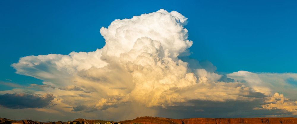
Cumulonimbus clouds
- Height of base: 1,100 - 6,500 ft
- Shape: fibrous upper edges, anvil top
- Latin: cumulus - heap; nimbus - rain cloud
- Precipitation: heavy rain and thunderstorms
Also called the King of Clouds, cumulonimbus clouds span the entire troposphere, known for their towering height and icy, anvil-shaped tops. Cumulonimbus clouds are menacing looking multi-level clouds, extending high into the sky in towers or plumes. More commonly known as thunderclouds, cumulonimbus is the only cloud type that can produce hail, thunder and lightning. The base of the cloud is often flat, with a very dark wall-like feature hanging underneath, and may only lie a few hundred feet above the Earth's surface.
How do cumulonimbus clouds form?
Cumulonimbus clouds are born through convection, often growing from small cumulus clouds over a hot surface. They get taller and taller until they represent huge powerhouses, storing the same amount of energy as 10 Hiroshima-sized atom bombs. They can also form along cold fronts as a result of forced convection, where milder air is forced to rise over the incoming cold air.
What weather is associated with cumulonimbus clouds?
Cumulonimbus clouds are associated with extreme weather such as heavy torrential downpours, hail storms, lightning and even tornadoes. Individual cumulonimbus cells will usually dissipate within an hour once showers start falling, making for short-lived, heavy rain. However, multicell or supercell storms contain many cumulonimbus clouds and the intense rainfall may last much longer.
If there is thunder, lightning or hail, the cloud is a cumulonimbus, rather than nimbostratus.
How do we categorise cumulonimbus clouds?
Cumulonimbus clouds have 3 distinct 'species' which describe the appearance of the head of the cloud:
- Cumulonimbus calvus - the top of the cumulonimbus is puffy, like a cumulus cloud. The water droplets at the top of the cloud tower have not frozen to become ice crystals.
- Cumulonimbus capillatus - the top of the cloud is fibrous but relatively contained. Water droplets have started to freeze, usually indicating rain has begun or will begin soon.
- Cumulonimbus incus - the top of the cloud is fibrous and anvil-shaped, as the cloud has continued to grow. If the cloud reaches the top of the troposphere and still wishes to grow, it must do so outwards, creating the picturesque anvil or 'incus'.