
UK storm season 2017/18
A summary of all the named storms from the 2017/18 storm season in the UK.
The 2017/18 storm season saw eight storms named over a period of ten months.
The first named storm was Storm Aileen on 12 September 2017 bringing gusts of up to 83 mph across the south of England.
The strongest gusts of the season were recorded during Storm Eleanor with 100 mph recorded at Great Dun Fell in Cumbria and Storm Dylan with 96 mph recorded at Cairngorm Summit .
A-Z of named UK storm names 2017/18
Name |
Date named |
Date of impact on UK and/or Ireland |
Max gusts and locations |
|---|---|---|---|
|
12 September 2017 |
12 - 13 September 2017 |
83mph - Needles, Isle of Wight 74mph - Mumbles, Wales 70mph - Avonmouth, Avon 67mph - Pembrey Sands, Wales 67mph - High Bradfield, Yorkshire |
|
|
11 October 2017 (Named by NHC) |
16 - 17 October 2017 |
90mph - Capel Curig, Gwynedd 90mph - Aberdaron, Gwynedd 81mph - RAF Valley, Anglesey 79mph - Mumbles Head, Glamorgan Republic of Ireland 97mph - Roches Point, Cork 84mph - Sherkin Island, Cork |
|
|
19 October 2017 |
21 October 2017 |
85mph - Needles, Isle of Wight 78mph - Aberdaron, Wales 78mph - Capel Curig, Wales 76mph - Mumbles, Wales |
|
|
5 December 2017 |
7 December 2017 |
93mph - Fair Isle, Scotland 85mph - Baltasound, Shetland 79mph - Altnaharra, Sutherland 82mph - Lossieouth, Moray |
|
| Dylan | 29 December 2017 | 30 - 31 December 2017 |
96mph - Cairngorm Summit, Grampian 76mph - Islay, Port Ellen, argyll 74mph - Needles Old Battery, Isle of Wight 70mph - Aberdaron, Gwynedd |
| Eleanor | 1 January 2018 | 2 - 3 January 2018 |
100mph - Great Dun Fell, Cumbria 90mph - Orlock Head, County Down 89mph - Needles Old Battery, Isle of Wight 84mph - Isle of Portland, Dorset |
|
16 January 2018 |
16 January 2018 |
85mph - Mace Head, Galway 74mph - Sherkin Island, Munster 71mph - Valentia Observatory, Co. Kerry 70mph - St, Mary's Airport, Isles of Scilly |
|
| David | 17 January 2018 (Named by Meteo France) | 18 January 2018 |
93mph - Capel Curig, Conwy 83mph - Tibenham, Norfolk 78mph - Aberdaron, Gwynedd 76mph - Lake Vyrnwy, Powys |
| Georgina | 23 January 2018 | 24 January 2018 |
85mph - South Uist, Western Isles 83mph - Capel Curig, Conwy 75mph - Needles Old Battery, Isle of Wight 74mph - Aberdaron, Gwynedd |
| Hector | 13 June 2018 |
13 - 14 June 2018 |
74mph - Orlock Head, Co, Down (NI) 70mph - Capel Curig, Conwy 67mph - Ballypatrick Forest, Co. Antrim (NI) 63mph - Malin Head, Co. Donegal (NI) |
Unused storm names for 2017/18
Iona, James, Karen, Larry, Maeve, Niall, Octavia, Paul, Rebecca, Simon, Tali, Victor and Winifred.
Storm Summaries
Storm Aileen: 12-13 September 2017
Storm Aileen was officially named on 12 September 2017 and impacted parts of the UK on 12 -13 September 2017. It brought strong winds and heavy rain overnight and into the morning rush hour causing disruption to roads and railways.
Many areas of England and Wales saw winds between 55 – 65 mph with the strongest gusts recorded on the Isle of Wight (83 mph) and Mumbles, Wales (74 mph). Across the north of England, over 7,000 homes were left without power.
Ex-Hurricane Ophelia: 16-17 October 2017
Ex-hurricane Ophelia (named by the US National Hurricane Center) was the second storm of the 2017/2018 winter season, following Storm Aileen on 12 to 13 September. The strongest winds were around Irish Sea coasts, particularly west Wales, with gusts of 70 to 80 mph or higher in exposed coastal locations.
The most severe impacts were across the Republic of Ireland, where three people died from falling trees (still mostly in full leaf at this time of year). There was also significant disruption across western parts of the UK, with power cuts affecting thousands of homes and businesses in Wales and Northern Ireland, and damage reported to a stadium roof in Barrow, Cumbria.
Flights from Manchester and Edinburgh to the Republic of Ireland and Northern Ireland were cancelled, and in Wales some roads and railway lines were closed. Ferry services between Wales and Ireland were also disrupted.
Storm Brian: 21 October 2017
Storm Brian was named by Met Éireann and impacted the British Isles on 21 October 2017.
Shortly after ex-Hurricane Ophelia, an area of low pressure began to rapidly intensify across the Atlantic and yellow and orange wind warnings were issues leading to Met Éireann naming the storm. Storm Brian brought strong gusts across the UK coinciding with highs tides. Impacts were most significant in Ireland and Wales with flash flooding in a number of Irish cities, while in Wales a number of seafront roads were closed and many ferries and trains cancelled.
Storm Caroline: 7 December 2017
Storm Caroline was named on Tuesday 5 December and brought gusts of up to 93 mph in Shetland on Thursday 7 December. Caroline was the fourth named storm of the 2017/2018 winter. The strongest winds were across the north of Scotland, especially the Western and Northern Isles, where wind gusts exceeded 80 mph. Cairngorm Summit recorded a gust of 124 mph.
Caroline brought transport disruption and schools were closed across the Western Isles. As the storm pulled away to the north-east it drew in a cold north-westerly airstream bringing snow showers overnight on the 7 and into 8 December. Lying snow caused some travel disruption across parts of north-east Wales, Staffordshire, Northern Ireland and the Isle of Man.
Storm Dylan: 30-31 December 2017
Storm Dylan was named by Met Éireann for a low pressure system that brought strong winds to Ireland and southern Scotland overnight Saturday 30 into Sunday 31 December 2017.
Storm Dylan affected the UK on New Year's Eve. This was the sixth storm of the 2017/2018 winter, and was a fairly typical Atlantic Storm, with winds gusting at 58 mph around exposed coastlines. There were reports of fallen trees across Northern Ireland, fallen trees in the south-west of England and some travel disruption. Snow and ice caused some travel disruption over the Pennines too.
Storm Eleanor: 2-3 January 2018
The storm brought strong winds across Northern Ireland and most of England and Wales. Wind gusts were widely between 60 and 70 mph around exposed coastlines but some inland locations also recorded gusts well over 60 mph, with 72 mph at Northolt (Greater London), which is fairly unusual in the London area.
The storm brought widespread transport disruption and power cuts with some fallen trees. Large waves affected the coast of the south and west, with a section of stone harbour wall collapsing at Portreath, Cornwall. There was also some fairly dramatic thunder and lightning in and around the Exeter area.
Storm Fionn: 16 January 2018
Storm Fionn was the seventh named storm of the 2017/2018 winter, named by Met Éireann for a period of strong winds that affected the Republic of Ireland on 16 January. Strong winds were recorded, especially across western counties, with the highest gust of 85 mph at Mace Head, Galway.
Gusts reached in excess of 60 mph around exposed western coastlines of the UK but impacts here were limited. Northern Ireland, on the other hand, experienced some travel disruption from heavy squally snow showers leading to some lying snow.
Storm David: 18 January 2018
Storm David was named by Meteo France, the French national metereological service, on 17 January 2018.
The storm brought strong winds to eastern parts of the UK before strengthening further as it crossed the North Sea and impacted northern Europe.
The strongest winds were across the southern half of the UK, with the south-east particularly affected as the storm intensified. Gusts exceeded 58 mph, even in inland areas including London, but the strongest gusts were in a swathe from North Wales through the south Pennines to Lincolnshire and Norfolk, where some inland locations recorded gusts exceeding 69 mph.
Storm David brought significant and widespread disruption to the UK, with over 100,000 properties without power, reports of fallen trees and rail services disrupted. Meanwhile, significant accumulations of lying snow across southern Scotland caused disruption on the roads - although much of this was from accumulations during the 16th and into the 17th.
As the storm moved into the near continent it caused further disruption across Holland and Germany (where the storm was named as Friederike).
Storm Georgina: 24 January 2018
Storm Georgina was named by Met Éireann and was the seventh named storm of 2017/18 .
Georgina was a fairly typical winter storm with maximum gust speeds of 60 to 70 mph around exposed coastlines, but gusts approached 60 mph inlands across parts of England and Wales. The strongest winds were near the centre of the low across northern Scotland, with the highest gust of 85 mph at South Uist, Western Isles.
Winds gusted close to 115 mph across the tops of the Scottish mountains and here there were very challenging conditions with snow at high levels adding to already very significant accumulations for the winter so far. The storm hampered the search for a missing hillwalker on Ben Nevis who had previously fallen through a cornice.
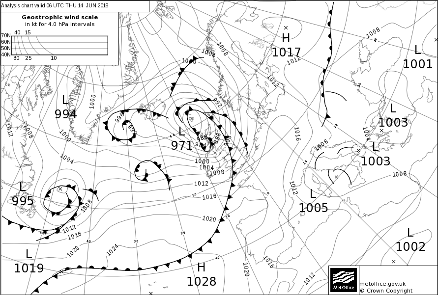
Storm Hector: 13-14 June 2018
Storm Hector was named by Met Éireann on 13 June 2018 with warnings issued for strong winds across the UK and Ireland.
Hector was the last named storm of the 2017-2018 season which brought heavy rain and strong winds across the north of the UK and Ireland throughout the 13th and 14th June. Met Éireann named the storm as an orange warning for wind was issued on the 13th June. The storm arrived after a week-long spell of hot and sunny weather.
 Strong winds brought disruption to road and rail services, with widespread reports of fallen trees. The Forth and Tay bridges in Scotland were restricted to high sided vehicles as was the Tees flyover in northern England. Ferry services were also affected. Reports of flying debris hospitalised one individual in Edinburgh. Meanwhile rough seas battered coastal communities. Widespread loss of power was reported in areas of Northern Ireland with up to 26,000 homes and businesses affected. Storm Hector did however bring a boost to the UK's energy supply in the form of wind power.