
Unusual cloud formations
The rarer and more unusual cloud formations including nacreous, lenticular and mammatus clouds.
There are a number of more unusual clouds that you could see, some are as additional features to low, medium or high level clouds, some have been formed by the forced uplift of air over higher ground (orographic clouds), and there are a few special clouds that are very rare and appear at high altitudes.
Supplementary features
Sometimes it is not possible to describe the cloud completely, they may have supplementary features, or could be accompanied by other, usually smaller clouds, known as accessory clouds. These are some of the supplementary features that you could see.
Virga
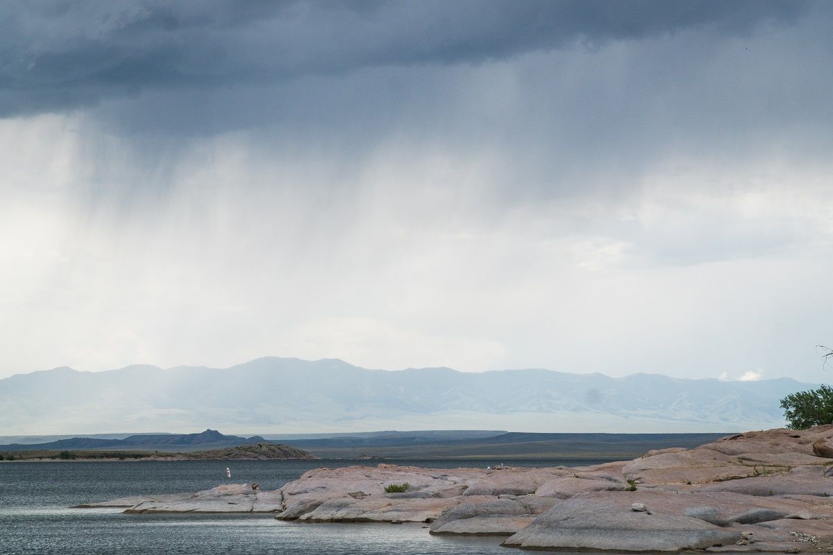
Virga, from the Latin for 'rod' or 'branch' appear as light wisps which are attached to the base of a cloud and are often at their most striking when lit by a red sunset with a light wind extending the tail into an angled curve.
How does virga form?
Simply put, virga are trails of precipitation that fall from the underside of a cloud but evaporate or sublime before it can reach the earth's surface. This happens when falling rain or ice passes through an area of dry or warm air.
What weather is associated with virga?
As you might expect, virga are associated with precipitation that does not reach the ground, often happening in isolated locations on sometimes, the finest of days. However, on some occasions, virga can lead to the development of microbursts, which pose a dangerous threat to planes and aircraft. These microbursts come about as rainfall transitions back into water vapour, removing heat from the air and causing an accelerating sink of colder air, which can cause severe turbulence.
The jellyfish of the skies
Virga are often referred to as 'jellyfish clouds' based on their puffy-top appearance with streaky stingers hanging below. Apart from jellyfish though, they are often spotted looking like various objects in the sky.
What clouds are associated with virga?
As a supplementary cloud feature, they occur most frequently with Cirrocumulus, Altocumulus, Altostratus, Nimbostratus, Stratocumulus, Cumulus and Cumulonimbus.
Arcus clouds
Arcus clouds are spectacular low-level, long and thin clouds associated with powerful thunderstorms. They are sometimes seen beneath Cumulonimbus clouds. Shelf clouds are attached to the storm cloud, whereas Roll clouds are a horizontal column separated from the storm cloud.
How do arcus clouds form?
When a cold downdraft from a cumulonimbus cloud reaches the ground, the cold air may spread rapidly along the ground, pushing existing warm moist air upwards. As this air rises, water vapour condenses into the patterns associated with Arcus clouds. The new cloud may roll if it experiences different wind directions above and below.
As Arcus clouds form with cumulonimbus clouds and downdrafts, they are associated with strong gusty winds, heavy rain or hail showers as well as thunder and lightning.
How do we categorize arcus clouds?
There are two types of Arcus clouds: Shelf clouds and Roll clouds.
Mammatus clouds
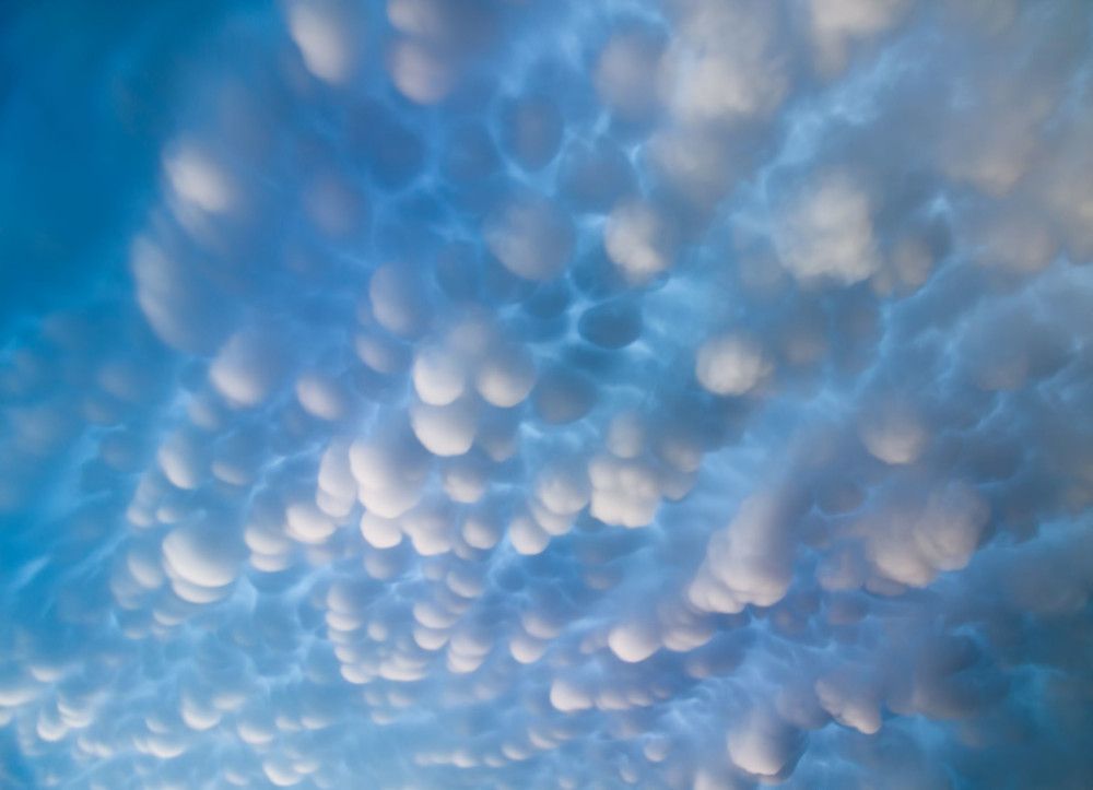
Mammatus clouds are some of the most unusual and distinctive clouds formations with a series of bulges or pouches emerging from the base of a cloud. The shape of mammatus formations can vary widely; from the classic protruding shape to a more elongated tube hanging from the cloud above.
Mammatus clouds are usually formed in association with large cumulonimbus clouds. Typically, turbulence within the cumulonimbus cloud will cause mammatus to form, especially on the underside of the projecting anvil as it rapidly descends to lower levels. This reverses the usual cloud-forming process of upward growth, making for an uneven cloud base.
What weather is associated with mammatus clouds?
Mammatus often forms in association with Cumulonimbus clouds, which in turn bring thunderstorms due to their huge mass of unstable air. Mammatus cloud generally form in the most unstable cumulonimbus, meaning that there is also a chance of hail, heavy rain and lightning in the vicinity, and if the air is cold enough during winter they can produce snow. Sometimes mammatus may form on other cloud types which produce no rain, though this is far less common.
Mammatus comes from the Latin mamma which translates to "udder" or "breast". Their striking appearance is most visible when the sun is low in the sky, and their pouches are framed by the sunlight. This supplementary feature is a firm favourite with many meteorologists as well as cloud and photography enthusiasts.
What clouds are associated with mammatus?
Mammatus usually form on the base of a cumulonimbus anvil, but they have also been sighted to form on other cloud types, such as stratocumulus, altostratus and altocumulus. Mammatus have also been observed to form on the underside of volcanic ash clouds.
Funnel clouds
Funnel clouds or 'tuba' are cone-shaped clouds that extend from the base of a cloud that reach towards the ground but never touch it. In the UK they often look like thin dangling bits of rope, hanging from the cloud above. But in hotspots such as tornado alley in the USA, funnel clouds can sometimes be thicker and much more intense.
How do funnel clouds form?
A rotating column of wind draws in cloud droplets, making a region of intense low pressure visible. They are formed in the same way as a tornado building around this localised area of intensely low pressure and are typically associated with the formation of cumulonimbus thunderclouds.
What weather is associated with funnel clouds?
Cumulonimbus clouds are almost always the host cloud from which tuba form, meaning that heavy rain, hail, thunder and lightning can all be expected. If a funnel cloud does make contact with the ground and produce a tornado, very strong winds can be expected in the immediate vicinity of the vortex potentially causing severe damage.
What is the difference between a funnel cloud and a tornado?
Crucially, a funnel cloud does not reach the earth's surface, at the point it reaches land it becomes a tornado, or if it reaches a body of water it becomes a waterspout. In a typical year, the UK sees around 30-35 tornadoes each year, though it is very rare that are they strong enough to cause any significant damage.
Orographic clouds
Orographic clouds are those which are formed by the forced uplift of air over high ground.
Banner clouds
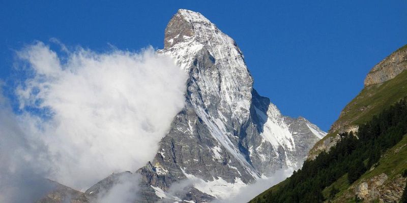
A banner cloud is one of a number of different cloud types that are grouped as orographic clouds. This defines them as being caused by the shaped of the land, with orographic (from the Greek óρος meaning 'hill') referring to the relief of land and mountains.
When the wind blows against a hill or mountain it is forced to lift. Air cools as it rises and the water vapour within it condenses to form a cloud. As the name implies, these clouds form in a layer and then remain also stationary as the wind continuously flows from one direction. The prevailing wind determines the particular microclimates found around a hill or mountain.
Areas to the leeward side of the hill can often experience shelter, with more sunshine, less rainfall and higher temperatures than areas to the windward side. Banner clouds form on the sheltered leeward side of the mountain.
Particular mountains, such as the Matterhorn in the Alps in Switzerland, have become famous for the frequent appearance of a banner cloud as pictured below.
Lenticular clouds
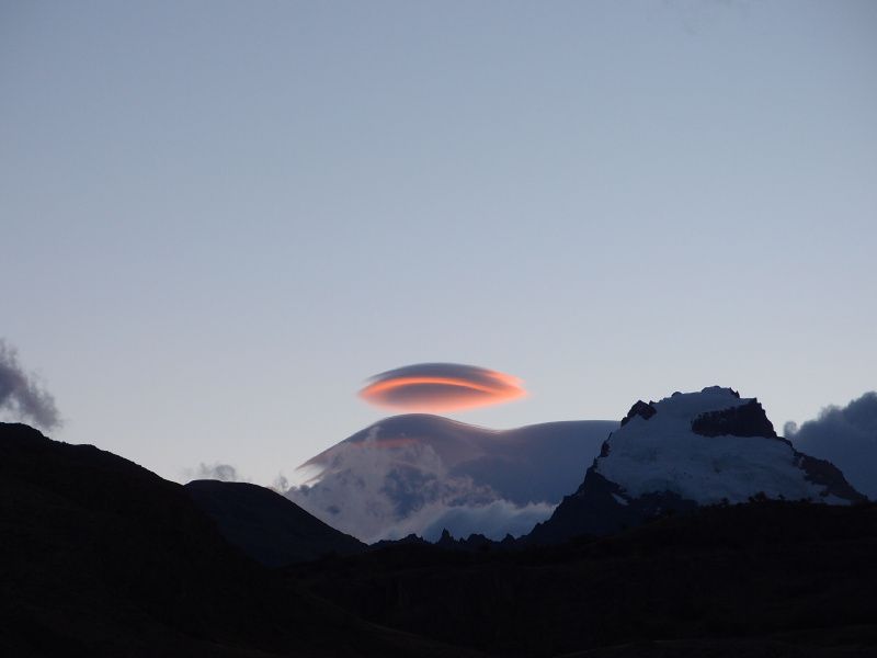 These strange, unnatural looking clouds sometimes form downwind of hills or mountains. They are quite unusual in the British Isles but do occasionally occur. They look a lot like the traditional shape of flying saucers in science fiction, and real lenticular clouds are believed to be one of the most common explanations for UFO sightings across the world.
How do lenticular clouds form?
When air blows across a mountain range, in certain circumstances, it can set up a train of large standing waves in the air downstream, rather like ripples forming in a river when water flows over an obstruction. If there is enough moisture in the air, the rising motion of the wave will cause water vapour to condense, forming the unique appearance of lenticular clouds.
What weather is associated with lenticular clouds?
Lenticular clouds are a visible sign of mountain waves in the air. However, these waves can be present beyond the clouds and may exist even when no clouds are formed.
On the ground, they can result in very strong gusty winds in one place, with still air only a few hundred metres away. Pilots of powered aircraft tend to avoid flying near lenticular clouds because of the turbulence that accompany them. Skilled (and brave) glider pilots, on the other hand, like them, because they can tell from the shape of the clouds where the air will be rising.
How do we categorise lenticular clouds?
There are three main types of lenticular clouds: altocumulus standing lenticular (ACSL), stratocumulus standing lenticular (SCSL), and cirrocumulus standing lenticular (CCSL), varying in altitude above the ground.
Special clouds
Nacreous and noctilucent clouds are rare and occur at high altitude.
Nacreous clouds
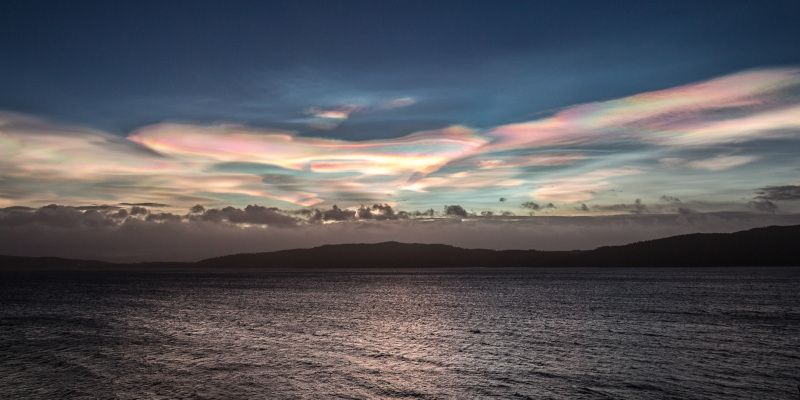
Nacreous clouds are rare and very high clouds, known mainly for the coloured light they reflect after sunset and before sunrise. The colours are reminiscent of the colours which reflect from a thin layer of oil on top of water, an effect known as iridescence.
How do Nacreous clouds form?
Nacreous clouds form in the lower stratosphere over polar regions when the Sun is just below the horizon. The ice particles that form nacreous clouds are much smaller than those that form more common clouds. These smaller particles scatter light in a different way, which is what creates the distinctive luminescent appearance.
Due to their high altitude and the curvature of the Earth’s surface, these clouds are lit up by sunlight from below the horizon and reflect it to the ground, shining brightly well before dawn and after dusk. They are most likely to be viewed when the Sun is between 1º and 6º below the horizon and in places with higher latitudes, such as Scandinavia and northern Canada. For this reason, they are sometimes known as polar stratospheric clouds. Nacreous clouds only form below -78 °C so are most likely to occur during the polar winter.
Because of the very low temperatures required, nacreous clouds are usually only visible from the UK when the cold air which circulates around polar regions in the stratosphere (known as the stratospheric polar vortex) is displaced and hovers temporarily over the UK.
What weather is associated with Nacreous clouds?
Because they form in a polar vortex, Nacreous clouds are associated mostly with very cold and dry weather.
How do we categorise Nacreous clouds?
Nacreous clouds are classified into three types, Ia, Ib and II, according to their chemical composition, height and ambient temperature.
Noctilucent clouds
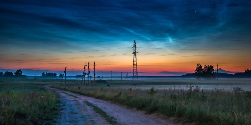
Noctilucent clouds are extremely rare collections of ice crystals, occasionally appearing in late clear summer evenings after sunset, but before it gets completely dark. They become visible about the same time as the brightest stars appear and often stay visible after dark because they are still reflecting sunlight due to their great height. They are higher up than any other clouds, occupying the layer of atmosphere known as the Mesosphere, and are only seen at latitudes between 45°N and 80°N in the Northern Hemisphere, and equivalent latitudes in the southern hemisphere. They are seen less often in the southern hemisphere as there is very little land and very few people there. Only the southern tip of Argentina and Chile, and the Antarctic are at the correct latitude.
How do Noctilucent clouds form?
Like many clouds, noctilucent clouds need water vapour, dust, and very low temperatures to form. Low temperatures are easily attainable in the Mesosphere, but water vapour and dust are in short supply. The dust may well come from tiny meteors from space, although dust from volcanoes or man-made pollutants may add to these. Scientists believe that the moisture comes through gaps in the tropopause or perhaps forms from the chemical reaction of methane and other chemicals.
What weather is associated with Noctilucent clouds?
These clouds are far too high to have any effect on weather on the ground.
How do we categorise Noctilucent clouds?
Many different patterns and shapes have been observed so attempts to classify or categorise them are difficult.