
What do satellite pictures show?
Satellite images are essential tools for understanding and forecasting the weather.
While they provide snapshots of current conditions, their real power lies in helping us anticipate what’s coming in the days ahead.
Seeing beyond the window
Looking out the window only reveals a small part of the sky and offers short-term clues about the weather. To predict further ahead, meteorologists rely on satellite images, which capture vast areas of the Earth at once. These images help verify forecasts and, when viewed in sequence, allow experts to track weather systems moving toward the UK and beyond.
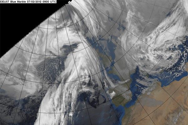
Tracking weather systems
Most UK weather systems form in the Atlantic and move eastward, sometimes originating as far away as North America. Satellite sequences show these systems developing, intensifying, or weakening before they reach the UK. This information is crucial for predicting whether to expect strong winds, heavy rain, or calmer conditions. Occasionally, systems form close to or over the UK, increasing forecast uncertainty.
Identifying cloud types
Satellite images help identify different cloud formations, such as shower clouds, fog, or thin clouds that let sunlight through. During the day, visible satellite images show where thick clouds are, though thin cirrus clouds are harder to spot. At night, satellites use thermal infrared imaging, which reveals cloud height by showing colder, higher clouds as bright white. This helps meteorologists distinguish between cloud types and predict weather events like showers or storms.
Types of meteorological satellites
Meteorological satellites fall into two main categories:
Geostationary satellites:
Positioned over the equator at 35,800 km, these satellites orbit the Earth every 24 hours, staying above the same spot. They provide continuous images of the atmosphere, making them ideal for monitoring weather systems affecting us. We contribute to the European Meteosat satellite, which is perfectly placed over the Greenwich meridian to observe weather that impacts the UK and Europe.
Polar orbiting satellites:
These satellites orbit much closer to Earth (about 850 km) and complete a circuit every 100 minutes, scanning wide swathes of the atmosphere from pole to pole. Their sun-synchronous orbits mean they view the same part of earth at the same local time each day. We contribute to the European polar orbiter, Metop, and use data from similar satellites operated by US agency NOAA and others.
Satellite imagery in practice
Since the launch of the first meteorological satellite in 1960, satellite images have become a staple of weather forecasts. Geostationary satellites provide movie loops that show cloud movement, while visible images offer a three-dimensional feel thanks to sunlight and shadows. Infrared imagery is used at night, with the highest, coldest clouds appearing white. Both types of imagery are processed to deliver valuable information about the atmosphere.
What can satellite images detect?
- Cloud coverage and temperature
- Rain-bearing clouds
- Wind speed and direction (inferred from cloud movement)
- Sea surface temperature
- Snow cover over land and extent of sea ice near the poles
- Fog, dust storms, pollution, and volcanic ash
Global satellite navigation systems
Signals from navigation satellites (like GPS) have meteorological uses. By measuring how water vapor slows a satellite signal, scientists can estimate atmospheric moisture, which is key for predicting thunderstorms. This technique helps identify areas of deep moist air that can trigger thunderstorms on hot days.
Altimeters
Some low-orbit satellites carry altimeters to measure the distance between the satellite and Earth’s surface. These measurements are especially valuable over oceans, helping track phenomena like El Niño and La Niña by monitoring sea surface height. Altimeter data also informs ocean models used for forecasting water temperature and movement, and helps measure wave height, wind speed, sea ice thickness, and long-term sea level rise. The data are particularly useful in the Ocean models we use for forecasting the temperature and movement of water at all levels in the ocean.
Doppler wind lidars
Doppler wind lidars on satellites use laser pulses to measure wind speed and direction by detecting the Doppler shift in light reflected from atmospheric particles. The first demonstration satellite by the European Space Agency launched in 2018, providing global wind data at various atmospheric levels.