Weather fronts
Weather fronts mark the boundary or transition zone between two air masses and have an important impact upon the weather.
Weather fronts are key to understanding the UK’s ever-changing weather. From cold and warm fronts to more complex occluded and waving fronts, these boundaries between air masses are crucial for understanding daily weather patterns in the UK.
What is a weather front?
Weather fronts are the boundaries where two different air masses meet, often resulting in significant changes in weather.
A weather front is the dividing line between two air masses with contrasting properties—such as temperature and moisture. Think of it as a ‘frontline’ in a battle: warm air on one side, cold air on the other. The greater the temperature difference, the stronger the front. For example, when very cold air meets warm tropical air, the resulting front can be intense, often bringing dramatic weather changes.
Why do fronts matter in the UK?
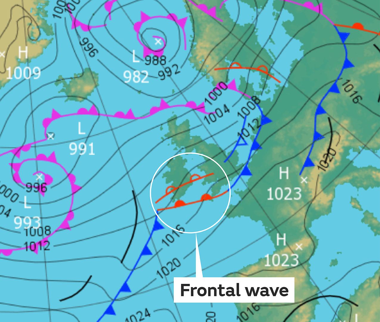
The UK’s unique position—an island with the Atlantic Ocean to the west and a large landmass to the east—means it frequently experiences weather fronts. Most of these systems form over the Atlantic and move west to east, bringing varied weather conditions. Met Office surface pressure charts show forecast pressure and weather fronts, out to five days ahead, for Europe and the northwest Atlantic. Three of the most common weather fronts displayed on these maps are explained below.
1. Cold fronts
- Symbol: Blue line with triangles (like icicles).
- What happens: Cold, dense air pushes under warmer air, replacing it at the surface. The direction of the triangles shows the movement of the cold air.
2. Warm fronts
- Symbol: Red line with semicircles (like half suns).
- What happens: Warm, lighter air rises over colder air, replacing it at the surface. The semicircles point in the direction the warm air is moving.
3. Occluded fronts
- Symbol: Purple line with both triangles and semicircles.
- What happens: Occurs when a cold front catches up with a warm front, lifting the warm air off the ground and ‘hiding’ it. Combines features of both cold and warm fronts
What Is a waving front?
A waving front (or frontal wave) is a disturbance along a cold front that slows its movement, often resulting in prolonged wet weather. Instead of the usual clearing after a cold front passes, a waving front can bring extended periods of rain. This happens when the atmosphere causes the cold front to ‘kink,’ creating a ripple effect. Sometimes, this wave interacts with the jet stream, forming a new area of low pressure and further complicating the weather.
While forecasting these features is improving with better computer models, waving fronts remain challenging to predict. They are small-scale and can develop quickly, making them hard for models to spot in advance.