
The atmosphere
The atmosphere is a layer of gases surrounding our planet, kept in place by its own weight under gravity.
Most weather events occur in the troposphere, the lowest layer, which extends up to 16 km (about 9 km at the poles). Above the troposphere are the stratosphere, mesosphere, and thermosphere, which extends up to 1000 km above the earth’s surface. The atmosphere hosts many processes fundamental to daily weather.
Air Masses: definition and importance
Air masses are large bodies of air that create distinctive weather conditions around the globe. Each body or ‘mass’ of air has uniform weather conditions such as temperature and humidity, and may cover millions of square kilometres and extend high into the atmosphere. Their characteristics are shaped by their source region and can be modified as they travel. When two air masses of different temperatures meet, a boundary called a ‘front’ forms, often leading to changes in weather.
Classification of air masses
Air masses are grouped by their temperature and humidity characteristics, and by their source region. The six main types that affect the British Isles are:
- Continental (originating over land)
- Maritime (originating over sea)
- Arctic/Antarctic
- Equatorial
- Tropical
- Polar
Air masses affecting the British Isles
Each of the air masses affecting the British Isles brings distinctive weather patterns.
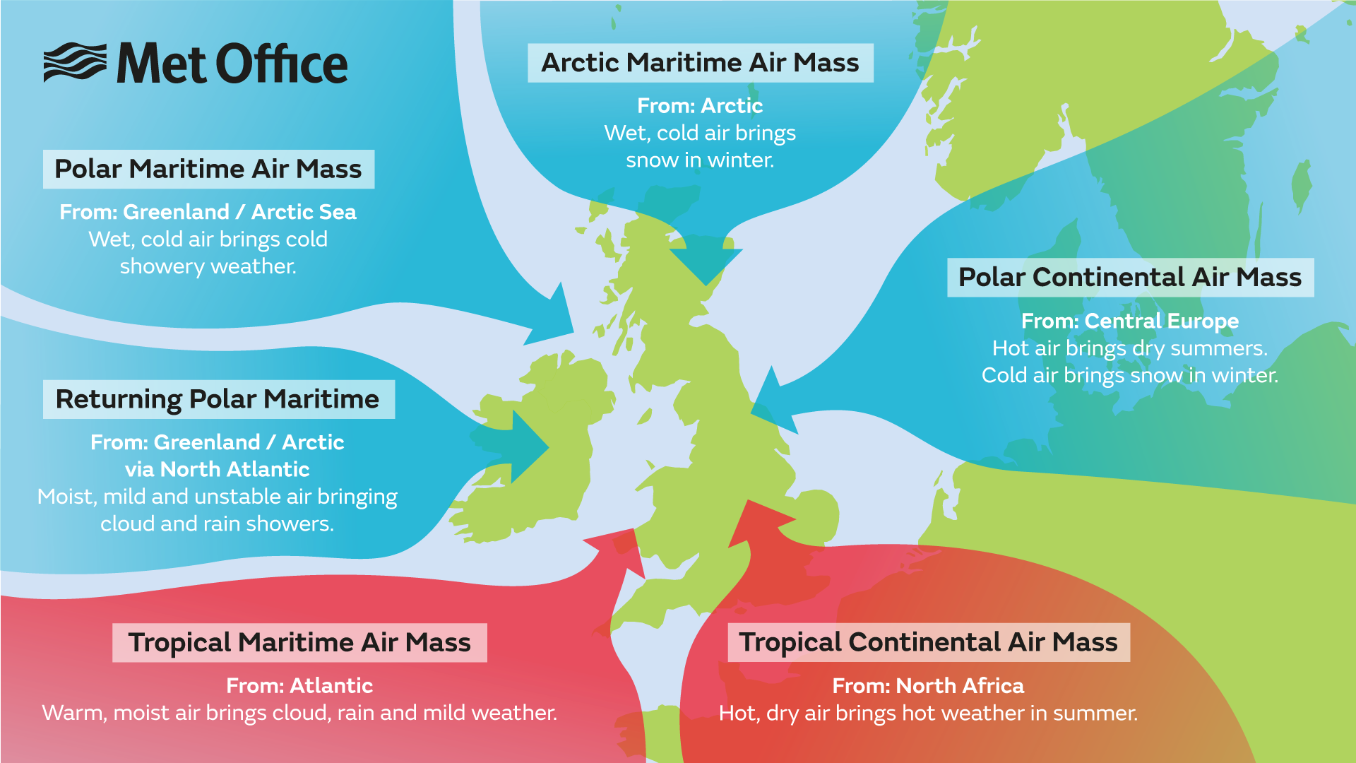
Polar continental air mass
- Origin: Central Europe
- Weather: Hot air brings dry summers; cold air brings snow in winter. A winter phenomenon, this air mass is very cold and dry, leading to clear skies and severe frosts if it crosses a short sea track, or showers of rain or snow if it crosses a longer sea track. The lowest temperatures in the British Isles usually occur under this air mass. During the summer with the land mass being warmer, it would be classed as a tropical continental air mass.
Polar maritime air mass
- Origin: Greenland/Arctic Sea
- Weather: Wet, cold air brings cold showery weather. It is the most common air mass affecting the British Isles, starting cold and dry but warming and becoming unstable as it passes over the relatively warm waters of the North Atlantic. It brings frequent showers at any time of year, with hail and thunder common in winter, especially in western and northern regions.
Arctic maritime air mass
- Origin: Arctic
- Weather: Wet, cold air; brings snow in winter. Similar to a polar maritime air mass but colder and less moist due to shorter sea track. Arctic air is uncommon during summer, but when it occurs it may bring heavy showers or thunderstorms and unseasonably low temperatures.
Tropical continental air mass
- Origin: North Africa/Sahara
- Weather: Hot, dry air brings hot weather in summer. It is most common in June, July, and August, and often responsible for our highest temperatures. It can also pick up Saharan dust, sometimes resulting in coloured rain.
Tropical maritime air mass
- Origin: Atlantic Ocean
- Weather: Warm, moist air brings cloud, rain, and mild weather. Emanating from the warm waters between the Azores and Bermuda, this south-westerly air mass often leads to low cloud, drizzle, and fog, especially around windward coasts and hills. In winter, it can raise temperatures above average.
Returning polar maritime air mass
- Origin: Greenland/Arctic via North Atlantic
- Weather: Moist, mild, and unstable air brings cloud and rain showers. Another version of polar maritime but with a longer sea track. It travels south over the North Atlantic, becoming unstable and moist, then moves north-east over cooler water, stabilising in its lowest layers. This air mass often brings extensive cloud cover.
Air mass modification
Air masses take on the properties of the underlying surface of their source region, which can be cold or warm and dry or moist. The stability of the air can also be derived. Tropical air is unstable because it has been heated from below and polar air is stable because it has been cooled.
As they move away from their source region, air masses are modified by the underlying surface. Maritime tracks increase moisture through evaporation of water from the sea surface, while continental tracks remain relatively dry. Cold air moving over a warmer surface becomes unstable, leading to unsettled weather, while warm air over a colder surface becomes stable. The stability of an air mass influences the likelihood of experiencing wind or rain.
Air mass source regions
The source region determines the main characteristics of an air mass. Warm air masses form over warm surfaces, and cold air masses over cold surfaces. The process of warming or cooling an air mass is gradual, requiring stagnation over a region. Areas where this can happen are called source regions. The main source regions include:
- Warm (tropical air masses): Sahara Desert (warm, dry), Tropical oceans (warm, moist)
- Cold (polar air masses): Arctic Ocean (cold, moist), Siberia and Northern Canada (cold, dry), Southern Ocean (cold, moist).